
42. STONEHENGE
Stonehenge was the last piece of the puzzle, the ending … where, in Homer’s language, a great glowing stone descended with doom … a star shot from heaven drawing a bright trail of light … buried its brilliance in the wood … Ilium was uprooted … overmastered with wounds it uttered one last groan and fell in ruin of fire and flood. Particularly the ‘flood’ … at the very end the planetary gods sent a flood which washed everything away.
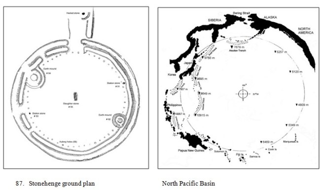
Stonehenge was the memorial of the fatal stone, that’s why in Old English the site was called Stanenges or Stonheng – the ‘stone fallen’ (from hengen, hanging down, fallen down). The recumbent stone originally in the centre of the circle was called the ‘Slaughter Stone’ – the stone that caused indiscriminate slaughter of Homer’s guiltless man. It was both a memorial and a map – a chart of exactly where on Earth the fatal stone fell. The epicentre.
But the map was not the Stonehenge that we see today, now dominated by the iconic, much-photographed trilithons that were added as much as 1000 years after the original earth circle. In fact the map was the original earth circle representing an impact crater – a shallow concave saucer with an outer ditch-bank ‘shockwave’ cut into the white chalk, with the haematite, ironstone ‘Slaughter Stone’ at the centre.
We don’t see the real crater now because it is underwater, and we hardly notice the memorial representation because it’s eroded and silted up and our attention is totally distracted by the photogenic trilitons – which were added later and have nothing to do with it. Perhaps we also don’t ‘see’ it because we intuitively expect the impact of a very large meteorite (asteroid) to leave an equally large crater. We expect a deep conical hole in the ground! But that is not the case. Large asteroid impact structures are typically almost flat shallow concave saucers surrounded by an outer perimeter ‘shockwave’. Like the gigantic craters on the moon (see Fig 1). The reason for that is that when a large meteorite (asteroid) impacts a solid surface its kinetic energy (of motion) is instantly transformed into heat – which melts the impact zone, which then behaves as a molten fluid. It makes a ‘slash’ like a stone dropped into mud.

There has been a great deal of nonsense written about Stonehenge over the years. Druids dancing and chanting and that sort of thing. In the 1960s British astronomer Gerald Hawkins claimed that Stonehenge was an astronomical observatory where various combinations of stones were aligned with certain solar, lunar and celestial events. But his analysis rested on several very convenient assumptions including the height of the horizon, the height of the observer, corrections for atmospheric refraction, whether to record an event at first glimpse or full emergence, on the left or right side of a marker stone, and he even ‘corrected’ the position or posture of certain stones which he considered to be ‘errors’. Despite these convenient assumptions and corrections, Hawkins’ theory remained fashionable in the late 20th-century, although some critics noted there are enough stones and enough stars that alignments are bound to point somewhere. Later Hawkins himself disingenuously admitted that even the key alignments were not exact … in order to photograph the Heel Stone (and sunrise) framed exactly between the sarsen stones … one has to place the camera about 12 inches to the west [of the true axis]. [1]
These days the current fashion is that Stonehenge was the site of ‘religious observances’ to which devotees flocked along the ‘processional way’ of the Avenue from the Avon River. But the physical evidence is weak – ‘The Avenue’ extends only about 500 m to the nearest gully after which it is a speculative dotted line for a hypothetical procession from the Avon. Nevertheless, perhaps Stonehenge could be considered religious in the broadest sense – it was certainly a memorial to the slaughter of mankind.
In fact the early earth circle was a memorial and a map, drawn en clair plain and simple for all to see. No Da Vinci code was required. The basic feature was a simple shallow concave saucer with the central area uniformly spread with stone chips, and with a perimeter ditch-bank ‘shockwave’. The shockwave trench was fairly uniform on the eastern sector but discontinuous and up to seven feet (2 m) deep on the western arc. Oxford Professor Atkinson who excavated in the mid-1950s described the series of pronounced western trenches as like a string of sausages. [2]
At the centre of the saucer was a single recumbent ‘Slaughter Stone’ – which has since been moved and is now in an anomalous eccentric position near the eastern side of the so-called ‘Entrance’. Flinders Petrie in 1880, recorded that the Earl of Pembroke told John Aubrey (ca. 1666) that there had originally been a stone at the centre, but it had been moved. [3] Amongst all the other stones the Slaughter Stone is uniquely haematite, ironstone.
Also in a pit in the centre, an excavation by Wm Hawley in 1924 found a human skeleton – which he may have sent to the Royal College of Surgeons in London, where it may have been destroyed by wartime bombing. Alas, it is now lost. [4] And the early explorer Wm Stuckeley (about 1723) recorded that much earlier a ‘tin plate’ had been found, engraved in Punic (Carthaginian/Phoenician) language – but it too has been lost. [5]
Just inside the ring of outer ditches is a regular circle of exactly 56 ‘Aubrey Holes’ (named by John Aubrey in 1666) – which were originally simple round holes about 1 m diameter filled with chalk so they appeared as white dots. Fifty-six is the unique characteristic atomic mass of iron.
Also in the ring are four distinct ‘Stations’, now numbered #’s 91-92-93-94 in the standard ground plan. Numbers 91 and 93 are single standing stones; while 92 and 94 are (were) regular conical earth mounds. And outside the ‘entrance’ to the northeast are two further notable features:
A single standing ‘Heel Stone’, inclined at an angle (now) of about 27 degrees from vertical; and two linear trenches (called ‘The Avenue’) leading away northeast for about 500 m, gently downhill to a natural gully where they stop.
Thus far the structure is clearly a model of ‘a crater’ – a concave saucer, spread with chipped stone debris, ringed by a shockwave accentuated in the northwest, caused by an ironstone meteorite – the ‘Fallen Stone’. But the question is ‘what crater’? Where is it?
Geographical interpretation requires a little background. Classical mythology says the great dragon Boreas, the demon, the devil, plunged into the dark seas of Styx, far, far away at the very ends of the Earth (from a European perspective). In a distant part of the world, the great ocean Eridanus received him. The dead were consigned to the fires of Phlegethon which became Hades in the ‘underworld’ – which is to say in the underside of the world. That ancient knowledge was retained by the Greeks at least as far as the historian Hecateus around 500 BC – who called Britons ‘Hyperboreans’. That is to say, the people of Britain were over or above Boreas, the dragon; or the other way around – Boreas was ‘under’ Britain, on the other side of the world.
Putting all that together, the impact site of the meteoric fire-breathing dragon Boreas was in a fiery region on the underside of the world from Britain – which is the Pacific basin, surrounded by the ring of fire. With that insight it is now easy to see that the Stonehenge earth circle was (is) a model of the Pacific Basin – which is a vast asteroid crater.
The Pacific Basin forms a single vast asteroid crater. It doesn’t contain a crater – it is a crater. A vast concave saucer with a volcanic ‘rebound’ peak at its centre (Hawaii), surrounded by an inner ring of deep ocean trenches (especially in the west), and an outer raised rim of high volcanic peaks (the ring of fire). Modern science recognises that there is a strong magnetic discrepancy in mid-Pacific, attributable to an anomalous layer of iron oxide on the ocean floor. [6] While others have noted that the ocean floor sediments contain very high levels of iron and nickel – an unnaturally high-level combination which implies an external source, characteristic of a substantial nickel-iron meteorite. [7]
Putting the maps together side-by-side (Fig x) it is evident that the Stonehenge model, even today about 5000 years later, represents the key features of the northern Pacific Basin. Particularly the deep, irregular ditches on the western fringe of the model clearly simulate the actual deep ocean trenches in the vicinity of the Philippines and Japan – implying that the impact event was at a slightly oblique angle, southeast to northwest. The ‘gap’ of the so-called ‘Entrance’ of the ground model represents the gap of the real Bering Strait between the landmasses of Siberia and Alaska; while beyond the gap to the north is the ‘Heel Stone’ which is the ‘heeled’ (tilted) stone representing the dislocated Earth axis now tilted at about 23.5 degrees (slowly decreasing).
In Classical myths Earth groaned as it received the mortal blow; the gods overturned its magnificence; Atlas shrugged and dropped his load; the great iron sword of Excalibur was thrust through the isle of man, from which no mortal could ever remove it. Poor mortal Anchises was struck by a thunderbolt and limped forevermore – as his Earthly axis was tilted. He joined the list of mythical characters who were wounded in the ‘underside’, right up to Jesus who was symbolically stabbed in the belly with an iron sword, thrust from below.
More than that, the ‘Slaughter Stone’ elegantly represents the actual nature of the meteorite – it was the iron sword of Excalibur. Uniquely among the other Sarsen stones of the model, the Slaughter Stone is haematite (ironstone), and in the rain it still sheds tears of blood. In case we didn’t get that subtlety the architects ringed the circle with 56 white dots, unequivocally denoting the atomic mass of iron. The atomic signature of iron.
Homer knew that – he had Achilles fling a meteorite, a missile [of] fused iron … five long years this lump will last, no need to go up to town for want of iron.
Amazingly even the surviving language is Homeric – it was a ‘slaughter’ stone, an indiscriminate massacre. The Iliad is dressed up as a battle but it was never an even fight. All throughout Homer bemoaned the destined fate of hapless and guiltless man, condemned by the celestial gods to an overwhelming slaughter. As Aeneas fled across the wild ocean he cried aloud to the cruel gods …
‘I am Aeneas of Troy, a remnant … what tract on Earth that is not full of our agony … we beseech thee, stay the dreadful flames, spare a guiltless race.’
But he cried in vain at the slaughter.
To locate the precise position of the Slaughter Stone the architects designed four ‘Stations’ around the perimeter to provide markers for a cross-bearing. Two of the ‘Stations’ (91 & 93) were standing stones; and the other two (92 & 94) were conical earth mounds with a hollow peak – like a volcano. Overlaying that model on a map of the Pacific reveals an obvious and unambiguous correlation with the four highest mountain peaks on the Pacific Rim (Fig. X). Not just the position of the peaks but also their identifying character.

Station # 91, a standing stone in the NE quadrant, corresponds with the solid stone massif of Mount Whitney (4421 m) just north of Los Angeles, the highest point in the continental Rockies.
Station # 92, an earth cone in the SE sector, corresponds to Mount Chimborazo (6310 m) in Peru, the highest isolated volcanic cone in the Central American region.
Station # 93, a standing stone in the SW quadrant, corresponds to Mount Pucak Jaya (4884 m) in Papua, Indonesia, a solid stone massif upthrust and the highest point in Oceania.
Station # 94, an earth cone in the NW sector, corresponds to Mount Fuji (3776 m) on Honshu Island, a near perfect isolated volcanic cone and the highest point in Japan (and in the region).
Taking a cross-bearing on those four markers gives a position of about 210 N latitude, 1600 W longitude, very close to the island of Kauai in the Hawaiian group. The fiery volcanic peaks of Hawaii are the characteristic central rebound peak of the Pacific crater – the mythical Isle of Fire in the midst of the world ocean surrounded by the suppurating volcanic sores on the Rim of Fire. It was the flaming region of Phlegethon which became the ‘underworld’ of Hades which became ‘Hell’. Or perhaps more prosaically it was the remnant of the Hawaiian continental homeland Ka-houpo-o-tane that now lies at the bottom of the ocean; or the New Zealand Maori homeland of Hawaiki which their lore says was once a ‘mainland’ with vast plains and a range of snowy mountains.
Finally, the present day model of Stonehenge features ‘The Avenue’ consisting of two parallel linear trenches leading away northeast from ‘The Entrance’. The two shallow ditches run gently downhill for about 500 m to a natural gully, then stop. Modern orthodox commentaries extend the so-called ‘Avenue’ further only as a dotted line because there is no evidence on the ground. The ditches stop at the gully (Fig 89). What is that all about?

All of the Classical literary accounts of the fall of Ilium end in a flood. In the finale the gods sent a flood that washed everything away. So too the Stonehenge model was constructed as a concave saucer with even deeper peripheral trenches – all of which, in Britain’s blessed climate, would catch and accumulate rainfall. The model would tend to flood. The simple answer to that potential problem was to construct drains – at each end of the deepest points of the peripheral trenches (at either side of the ‘Entrance’) they constructed simple open trench drains that ran down to a natural gully – and eventually into the nearby Avon river. Speculatively, they may even have controlled the drains so as to deliberately allow the crater to flood for demonstration purposes.
As was the case at Woodhenge, Stonehenge was an apparently simple earth circle yet containing elegantly subtle imagery and language. It was a marvellously eloquent record of Earth’s history which has only just survived the ravages of time.
Now the lords’ job was done so they returned to their ancestral home. No grave or burial or body of any ancient king of this era was ever found in Britain, nor in Egypt, nor in the Middle East – they all returned home to die.
[1] Hawkins, Stonehenge Decoded; Hawkins, Beyond Stonehenge
[2] Atkinson, Stonehenge
[3] Flinders Petrie, Stonehenge: Plans, Descriptions and Theories
[4] Pitts, Hengeworld
[5] Stuckeley, Stonehenge A Temple Restored to the British Druids
[6] Runcorn, Polar path in geomagnetic reversals. Nature,1992
[7] Allan, & Delair, When the Earth Nearly Died
