
38. THE BIG PICTURE
The first-stage macro diagram illustrated our entire solar system, along with the intrusion of external astral debris into collision with Uranus.
Having established the landscape of Britain as a model of the night sky, emblazoned with the diagonal silver baldric of the Milky Way, the lords now added white-chalk mounds to mark the planets. These were Hesiod’s ‘silver bosses’ on the green landscape. All the planets were there in clearly recognisable relative size and position still with evocative names and folklore … all in order – the Sun, Mercury, Venus, Earth, Mars, Jupiter, Saturn, Uranus, Neptune, Pluto.
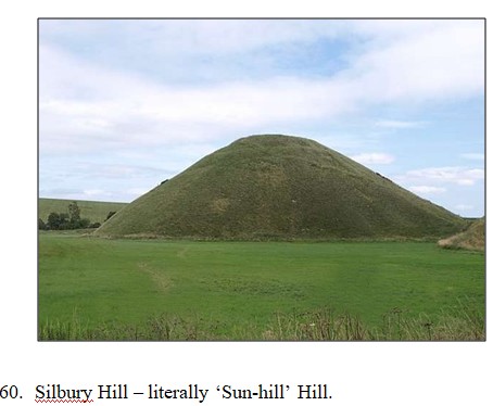
The sun was represented by Silbury Hill, where ‘Sil’ is a variant of ‘Sol’ – the sun.
Silbury is the very largest of all the mounds at 40 m high and 160 m diameter located close to Avebury. But it is oddly situated in a small valley so it is not prominent on the general landscape. The hill has been excavated several times, the last by Atkinson in 1962, and has been reliably C-dated to 2660 BC. The construction is solid radial layered earth and chalk – containing nothing at all. It is not a tomb. Local folklore says it is the home of a giant king of solid gold – familiar imagery for the golden sun king.
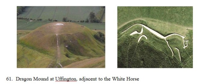
Mercury was embodied as the appropriately small mound of Dragon Hill at Uffington, with the familiar White Horse on the adjacent hillside.
In myth, Mercury was characterised variously as the valiant White Knight companion of Venus; and as the messenger of the gods galloping across the sky on his white horse; and finally as the ‘dragon’ or devil Woden who caused the final fatal collision with Mars and then Earth. Dragon Hill is located at Uffington which is a variant of ‘Offington’ – meaning ‘nearby’ as in the phrase ‘in the offing’ – which characterises the actual position of Mercury ‘nearby’ the sun.
Venus was represented by another small (18 m) mound, now in the grounds of Marlborough College in the nearby town of Marlborough, about 10 Km east of Silbury Hill.
The mound is now somewhat forlorn and neglected but it was intact and well-formed when illustrated by antiquarian Wm. Stuckley in 1723. The symbolism of Venus is revealed in the name of Marlborough where ‘marl’ means fertiliser or ‘to fertilise’ and borough is a variant of burgh meaning hill. So Marlborough means ‘Fertility Hill’, capturing the characterisation of Venus/Aphrodite as a mother/lover /beauty. It was Mons Veneris, the mound of Venus.
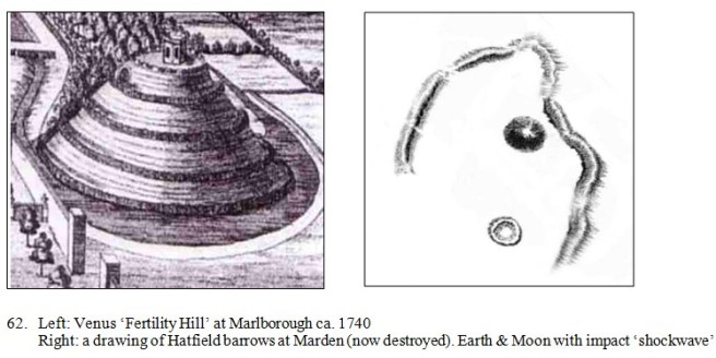
Earth, with its Moon, was represented by the Hatfield Barrows, also known as Marden Henge, about 10-15 km south of Silbury.
The main circular mound (now destroyed) has been variously reported at 60-150 m in diameter and 7-15 m high, with a much smaller companion, together partially surrounded on the northern side by an earth ditch/bank arc. The mounds were excavated in 1807 revealing a few animal bones, and thereafter the remains collapsed and were substantially destroyed by farming activities. Alas! Identification of Hatfield as the Earth and Moon is apparent from its geographic position relative to Silbury, and from the unique composition of a planet plus a single large moon; together with the partial ditch/bank arc characterising an impact shockwave on the northern arc. The location is also very cunningly contrived within a loop of the Avon River so the structure is almost surrounded by water on three sides – just as is uniquely the case for planet Earth. It’s the watery planet, especially in the south. The significance of the name Hatfield is unclear, possibly recent; while the locality name Marden is possibly a variant of Mor-dun signifying ‘Death Hill’.
Mars was clearly represented by Old Sarum Hill at Salisbury, about 40 Km south of Silbury.
Old Sarum Hill is a chalk mound, about 100 m diameter, with an oddly flattened top surrounded by a ditch/bank structure – like an impact shockwave. The symbolism of Mars is apparent from the flattened (impacted) top, like the real Mars; and from the names. Salisbury is derived from Salii’s bury, literally Mars Hill, from the Roman Salii priests who managed the rites of the dies Martis festivals of Mars. While Sarum is contracted from earlier Sorbiodunum, meaning ‘Harmful Hill’.

These earth-chalk mounds were the ‘silver bosses’ of Hesiod’s Shield from around 700 BC; and were again recorded by Diodorus in the 1st century BC, in turn quoting from the eye-witness accounts of Hecateus from the 6th century BC. Diodorus wrote that the early Greeks had visited the land of the Hyperboreans (Britons) and vice versa. The Hyperboreans had a magnificent circular temple of Apollo and also on this island certain eminences of a terrestrial form are plainly seen. It was also said that ‘the moon was very close to the Earth’ – implying direct observation of the sculpture of the Hatfield mounds.
Thus far the five ‘inner’ planets – Mercury, Venus, Earth (& Moon) and Mars – were fittingly portrayed as terrestrial mounds on the land of Britain. But now the architects of the grand design cunningly placed the remaining gas-giant ‘outer’ planets Saturn, Uranus and Neptune (plus Pluto) offshore – denoting their position in the outer circle of our solar system.
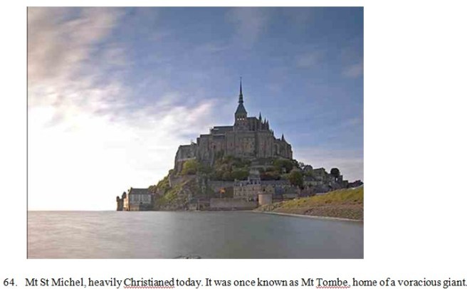
Jupiter (Zeus), the giant of the system, was represented as the man-modified island of Mont St Michel, near St Malo, Brittany.
In Classical mythology, Jupiter (Zeus) was a voracious, rampant giant who cast lightning and thunderbolts and captured, ravaged and ate anyone in his vicinity – even his own children. Just as in 1994, comet Shoemaker-Levy was drawn into the aegis of Zeus where it split into twenty-odd fragment ‘children’ which were promptly ‘eaten’ with explosions of fire visible from Earth. Now very heavily Christianised, Mont St Michel was earlier known in local legend as Mont Tombe, the home of a voracious giant who lit enormous fires to attract and capture hapless maidens whom he ravaged and killed – the very epitome of both the Classical Zeus and the real Jupiter.
Later in the sculpture Jupiter would again exert his gravitational influence to divert the paths of passing comets Venus and Mercury, to draw them into a fatal dance in the inner solar system.
Saturn was portrayed as the large earth mound of ‘Knowth’, in the valley of the Boyne northwest of Dublin, Ireland. It is [now] 67 m in diameter and 12 m high and is surrounded by 18 regular moons – the unmistakable signature of Saturn.
Knowth mound is located nearby the smaller mound of ‘Dowth’ and the popularised stone mound now called ‘Newgrange’ – altogether in the valley of the Boyne in an area that was called Bru na Boinne meaning ‘mansion of the Boyne’, reputed in folklore to be the burial ground of kings following the ‘battle of destruction’. It was not a human battle but a clash of the planets that lead ultimately to the near-fatal destruction of Earth.

Uranus is located nearby as the nondescript and neglected earth mound of ‘Dowth’, earlier known in Celtic as Dubad – meaning ‘darkness’. Identification as Uranus derives from the name Dubad (‘darkness’) since Uranus is a dim, featureless ‘dark’ planet not known to modern science until observed by Herschel in 1781. But Uranus was known in many ancient mythologies and named in terms signifying darkness and death. In Greek myth, Ouranos was the father of Cronos (Saturn), killed and ‘castrated’ by the twelve Titans.
The earth mounds of Knowth and Dowth are located together near Drogheda in the Boyne Valley, along with the ‘foreign’ stone mound now called ‘Newgrange’ – more of that later.
Incidentally, the four man-made mounds in Ireland (including Neptune, below) are dated from about 3200 BC – at a time when there are no records of a contemporaneous sophisticated local population. What few records there are indicate scant population at all at that time. That is a problem for orthodox interpretations but of course it should not be surprising since folklore says the mounds were built by foreign ‘Saracen’ giants – the lords from Egypt.
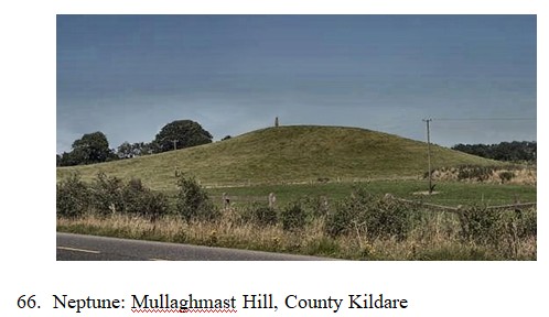
Planet Neptune is recognised by modern science as having an unusually ‘hot’ core – which corresponds to its mythological characterisation as the home of Vulcan (Hephaestus), the smithy, god of the forge. It may be identified in the ground diagram as the earth mound of Mullaghmast Hill in County Kildare, southwest of Dublin. Mullaghmast Hill is reputed to be the home of Goibniu (Gobha) the primary Irish ‘smith god’ who forged magic weapons for the gods; possibly synonymous with Culann, another [later] smith god. This identification is a little uncertain because Irish mythology derives from several cycles of oral tradition leaving a number of ‘smithy’ characters and possible regional locations. Ultimately the precise location doesn’t matter because Neptune was not a direct participant in the ‘dance of the gods’ (planets), rather only a spectator.
Coincidentally, local folklore says Stonehenge was made by ‘giants from Kildare’ in Ireland – as if they completed the Irish part of the diagram first (about 3000 BC) before moving on to the mounds and stone circles in Wessex.
Finally, tiny distant Pluto (Hades) which, although now not recognised by the International Astronomical Union, was definitely a key player in the mythological accounts. Pluto was (and is) a tiny glowing planet far, far distant – out of sight – at the extremity of the solar system. To accommodate this scale on their ground diagram the lords represented Pluto as the tiny, fiery island of Hawaii – out of sight, over the horizon, a tiny ‘glowing’ island in the midst of a vast ocean (of space).
The subtly of the imagery is amazing – Hawaii as Pluto ticks all the boxes. It is tiny, glowing, out of sight, and lost in the vast ocean of space. In humanised mythology it became Hades, the realm of the dead amid fire and fumes of the celestial ‘dragon’ (from the impact site) – which was later Christianised as ‘hell’, home of the ‘devil’ and of the dead. Hades and hell were naively characterised as in the ‘underworld’ – simply meaning they were on the ‘underside’ of the world (from a European perspective). What the ancients called the ‘underworld’ we now simply call ‘downunder’.
Now all the planetary players were assembled on the stage, crafted onto the landscape of Armorica. The scale and sophistication of the diagram was awesome. They got all the planets characterised and still identifiable, more or less in proportion, in correct relative position and in alignment. The planets are arranged on a single plane as they should be, with its axis inclined at about 60 degrees to the axis of the Milky Way (the Ridgeway). As it should be. It is unequivocal that the ancients understood the geography of the solar system and they exercised incredible skill in design and construction to render it into a ground diagram. But unfortunately we didn’t appreciate it; we didn’t even see it.

67. The planets embossed on the great shield of Amorica.
With all the planets in position the lords now added the final touch of the celestial intruder, the cosmic debris that entered the system and ‘put the stars to flight’. It is difficult to be definitive about the dynamics from a static diagram, especially since many of the fine details on the ground are now missing. However, there are enough clues left both on the ground and in regional mythology to be confident of the general pattern of events.
